
Street Types & Classifications
Every pattern page in this guidebook is sorted two ways: by its Functional Classification and by its Street Typology. Those aren't everyday words, so this page explains what they mean, in plain language, before you run into them everywhere else in the guidebook.
#The question every street has to answer
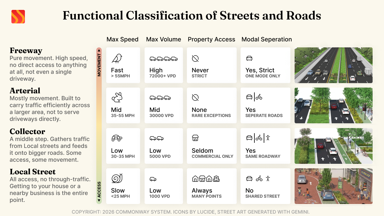
Every street is pulled between two competing jobs: helping people move through quickly, and helping people access the homes and businesses along it. A street can't fully do both at once. A road built for fast through-traffic works badly as a place with driveways and parked cars every few feet; a residential street built for slow, safe access to houses works badly as a high-speed route across town.
Functional Classification is just naming where a street sits on that trade-off. Commonway System uses four, the same categories used to classify roads across the US highway system:1
| Classification | Job it's built to do |
|---|---|
| Local | All access, no through-traffic. Getting to your house or a nearby business is the entire point. |
| Collector | A middle step. Gathers traffic from Local streets and feeds it onto bigger roads. Some access, some movement. |
| Arterial | Mostly movement. Built to carry traffic efficiently across a larger area, not to serve driveways directly. |
| Freeway | Pure movement. High speed, no direct access to anything at all, not even a single driveway. |
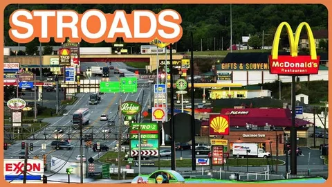
There's a real-world example of what goes wrong when a street tries to do both jobs badly at once: it's called a Stroad2, a road that tries to move fast traffic and serve strip-mall driveways and parking lots at the same time. It ends up dangerous for the same reason a car can't be a good boat: trying to do two very different jobs at once usually means doing neither one well. Commonway System flags Stroad as a pattern to avoid, and most of what a Collector or Arterial page in this guidebook recommends is really just a way of keeping those two jobs from colliding.
Related Media

#Why a bike path or a bus route gets a car-sounding label
You'll run into pattern names like "Collector" attached to a bike path, or "Local" attached to a bus route, and that can look like a mistake at first. It isn't. Functional Classification isn't really about cars, it's about the job being done, and any mode of travel can do any of these jobs.
A dedicated bike path connecting one neighborhood to another is doing exactly the job a car Collector does, just for bikes instead of cars, so it's classified as a Collector. A car-free plaza that exists purely so people can walk to shops and linger is doing the same job a residential street does, just without cars, so it's classified as Local. The same logic sorts transit: a neighborhood bus loop plays a Local role, a bus route feeding a larger transit line plays a Collector role, a light-rail spine crossing a whole city plays an Arterial role, and commuter or heavy rail plays a Freeway-scale role. Once you're thinking in terms of the job rather than the vehicle, the classification makes sense for any mode.
#From classification to a specific street
Knowing a street's Functional Classification tells you its general job. It doesn't tell you the specific situation it's handling. That's what a Street Typology3 is: a named, specific pattern within a classification, built for one clear purpose.
Think of it like this: Functional Classification answers "what job is this street doing?" Street Typology answers "what particular kind of street is doing that job?" An Alley and a Main Street are both Local, both are pure access with no through-traffic, but they're built for completely different situations: one is a service lane behind buildings, the other is a shopping street meant for browsing on foot. Same classification, very different street.
Every classification has a Default Typology: the standard, ordinary version of that classification, with no special situation attached. A pattern only gets its own named Typology when it's built around something specific enough to deserve a name of its own, a particular access pattern, a particular land use, or a single mode getting full priority.
#Every Street Typology in the guidebook
Most of the names below aren't invented for this guidebook. Many trace to established American design guides, particularly NACTO's Urban Street Design Guide,4 cross-referenced against how each pattern is actually used in the field.
#Local
| Typology | What it is |
|---|---|
| Default | The standard neighborhood street. No special job beyond getting people to and from home. |
| Alley | A narrow service lane behind buildings, mainly for deliveries, trash pickup, and driveway access. |
| Cul-de-sac | A dead-end residential street that loops back on itself. |
| Frontage/Service Road | A quiet local street running alongside a busier road, keeping people out of fast through-traffic. |
| Main Street | A local street lined with shops and restaurants, built for browsing on foot as much as driving. |
| Living Street/Woonerf5 | A street where people walking and biking always have the right of way, and cars are guests, not the priority. |
| Yield Street6 | A low-traffic street with no dedicated travel lanes; whoever's already there has the right of way. |
| Festival Street | A street that closes to cars for markets or events, and behaves like a normal local street the rest of the time. |
| Pedestrian-only Street/Plaza | Closed to vehicles entirely, built just for walking and sometimes biking. |
| Local Transit | A street built around a neighborhood bus or streetcar route. |
| Bicycle Boulevard/Neighborhood Greenway | A quiet residential street specifically designed to prioritize bikes over car traffic. |
| School Street | A street that closes to car traffic during drop-off and pickup to keep kids safe. |
#Collector
| Typology | What it is |
|---|---|
| Default | A standard street that gathers traffic from Local streets and feeds it onto bigger roads. |
| Rural Collector/Farm-to-Market Road | A collector serving farms and rural areas, carrying both people and agricultural traffic. |
| Industrial Collector | A collector built to handle truck traffic serving warehouses and industrial sites. |
| Bike Highway/Greenway | A dedicated, physically separated path built specifically for bikes over real distance. |
| Collector Transit | A collector street built around a dedicated bus route. |
#Arterial
| Typology | What it is |
|---|---|
| Default | A major road built to move traffic efficiently across a larger area, without driveways or on-street parking interrupting the flow. |
| Boulevard | A grand arterial, often with a landscaped median and sometimes separate slower side lanes for local access. |
| Scenic Highway/Byway | An arterial through a scenic or rural landscape, where the drive itself matters as much as the destination. |
| Arterial Transit | A major road built around dedicated bus rapid transit or light rail. |
| Stroad | A hybrid that tries to be both a fast through-road and a shopping strip at once, and does neither safely. This is the pattern Commonway System is built to help communities move away from. |
| One-Way Street | Traffic moves in one direction only. Tends to encourage speeding, so it's discouraged except in specific situations. |
#Freeway
| Typology | What it is |
|---|---|
| Default | A limited-access, high-speed road with no traffic lights or driveways, built purely to move large volumes of vehicles. |
| Expressway | A slightly less restricted freeway variant, still built purely for movement. |
| Beltway/Ring Road | A freeway that loops around a city rather than cutting through its center. |
| Freeway-scale Transit | Heavy or commuter rail running at the same scale as a freeway corridor. |
#Intersections & Crossings
Every classification above describes a stretch of street. Intersections & Crossings is different: it describes how two streets meet, and it applies across all four classifications rather than belonging to just one.
| Typology | What it is |
|---|---|
| Roundabout | A circular intersection that keeps traffic moving continuously instead of stopping. Commonway System's default choice for busier intersections. |
| Turbo-Roundabout7 | A larger, multi-lane roundabout for high-volume intersections between two major roads. |
| Signal | A traditional traffic light, used only when a roundabout genuinely isn't practical. |
| All-Way Stop | A four-way stop. |
| Stop/Yield | A basic two-way stop or yield-controlled intersection. |
| Continuous Sidewalk/Raised Junction | A crossing where the sidewalk stays level and uninterrupted, and cars ramp up over it, rather than the sidewalk dipping down for cars. |
| Uncontrolled | An intersection with no signs or signals at all, appropriate only where traffic is very light. |
| Midblock Pedestrian Crossing | A marked crossing placed in the middle of a block rather than at an intersection. |
| Driveway/Curb Cut | Where a driveway meets the street. |
| Grade-Separated Interchange | A freeway-scale interchange where roads cross at different heights entirely, like an overpass. |
#Why this matters once you're reading a pattern page
Every Segment/Intersection-scale pattern's ID starts with its Functional Classification (LOC, COL, ART, FRE, or INT), follows with a code for its specific Typology, and ends with a number, for example LOC-DEF-01 for the standard Local street. These five prefixes apply specifically to the Segment/Intersection scale, alongside four other flat Scale prefixes (NET, CDR, FAC, ELM) covering Network, Corridor, Facility, and Element patterns, which don't subdivide by classification. See Pattern IDs for the full nine-prefix ID scheme, Scale Hierarchy for what each Scale covers, and Density Tiers for the other axis every pattern page is sorted by, alongside classification and typology.
#For readers coming from Dutch (CROW) practice
If you're familiar with Dutch road design, Duurzaam Veilig, or CROW's manuals, you'll recognize a lot of the underlying thinking here even though the categories don't map cleanly onto each other. Commonway System sorts streets by the job they do, movement versus access. Dutch practice sorts primarily by design speed and how completely different modes are physically separated. There's no perfect one-to-one translation, but most CS patterns have a close Dutch relative worth knowing.
| Source Manual | Category/Type | Closest CS equivalent | Area | Cross-section | Speed | Mode separation | Other differentiator |
|---|---|---|---|---|---|---|---|
| Duurzaam Veilig | Nationale stroomweg | Default (Freeway) / Expressway | Outside built-up | Min. 2×2, full physical lane separation | 120 km/h (~75 mph) | Full (grade-separated) | National-scale |
| Duurzaam Veilig | Regionale stroomweg | Expressway / Beltway / Ring Road | Outside built-up | 2×1 to 2×2, physical direction separation | 100 km/h (~60 mph) | Full | Connects regions |
| Duurzaam Veilig | Gebiedsontsluitingsweg I | Default (Arterial) | Outside built-up | 2×2, physical separation | 80 km/h (~50 mph) | Bikes banned, routed elsewhere | No erf access |
| Duurzaam Veilig | Gebiedsontsluitingsweg II | Default (Arterial) | Outside built-up | 2×1, paint separation | 80 km/h (~50 mph) | Bikes banned | Priority-road rules |
| Duurzaam Veilig | GOW50 | Default (Arterial) | Inside built-up | 1 to 2 lanes/direction | 50 km/h (~30 mph) | Separated bike paths | Standard urban distributor |
| Duurzaam Veilig | GOW30 (hybrid) | Boulevard (loose match) | Inside built-up | Same as GOW50 | 30 km/h (~20 mph) | Bike separation often reduced | Emerging (Amsterdam) |
| Duurzaam Veilig | Erftoegangsweg I | Frontage / Service Road, Rural Collector / Farm-to-Market Road | Outside built-up | 1 shared carriageway | 60 km/h (~35 mph) | Marked bike strip/path | |
| Duurzaam Veilig | Erftoegangsweg II | Default (Local) | Outside built-up | 1 shared carriageway | 60 km/h (~35 mph) | None, bikes ride in road | Equal-priority junctions |
| Duurzaam Veilig | ETW-30 (urban) | Default (Local) | Inside built-up | 1 shared carriageway | 30 km/h (~20 mph) | Mixed traffic | Destination traffic only |
| Duurzaam Veilig | Woonerf | Living Street / Woonerf | Inside built-up | No marked lanes, shared surface | 15 km/h (~10 mph) | None, peds have priority | No roadway/sidewalk distinction |
| Ontwerpwijzer Fietsverkeer | Fietssnelweg (bicycle expressway) | Bike Highway / Greenway | Any, own alignment | 4m+ two-way path | 20 to 30 km/h design (~10 to 20 mph) | Full, bikes only | Long-distance, minimal stops, built for e-bike speeds |
| Ontwerpwijzer Fietsverkeer | Solitair fietspad | Bike Highway / Greenway | Any, own alignment | 2 to 4m path | n/a | Full, bikes only (or +mopeds) | Independent of the road network (park, shortcut) |
| Ontwerpwijzer Fietsverkeer | Vrijliggend fietspad | Cross-section attribute, not a discrete CS typology | Alongside a road | 2 to 2.5m one-way, wider two-way | n/a | Physical curb/median separation from cars | Mandatory alongside GOW roads under Duurzaam Veilig |
| Ontwerpwijzer Fietsverkeer | Fietsstraat | Bicycle Boulevard / Neighborhood Greenway | Inside built-up, local streets | Shared carriageway, bike-priority markings | 30 km/h (~20 mph) | Shared, cars are guests | Cars permitted but bikes are the primary user |
| Ontwerpwijzer Fietsverkeer | Fiets(suggestie)strook | Cross-section attribute, not a discrete CS typology | On-street, any tier | Painted stripe, no barrier | n/a | Paint only, cars can cross/park over it | Lowest protection level, used where space is tight |
| Richtlijn inpassing tram | Tram (mixed traffic) | Local Transit / Collector Transit | Inside built-up | Shares the traffic lane | Matches host road | None | Runs in-lane with cars |
| Richtlijn inpassing tram | Tram (reserved lane/median) | Arterial Transit | Inside built-up | Dedicated median or curb lane | Higher than mixed | Physical separation | Common on GOW-scale streets |
| Richtlijn inpassing tram | Tram (tunnel/grade-separated) | Freeway-scale Transit | Any | Dedicated tunnel or elevated | Highest | Full | Same treatment as heavy/light rail |
Sourced from CROW's own categorization framework,8 bicycle design manual,9 and tram integration guideline.10
Two things this table can't capture cleanly. Vrijliggend fietspad and fiets(suggestie)strook don't get a real CS equivalent, since CS treats bike separation as a cross-section detail layered onto Local, Collector, or Arterial, while Dutch practice treats the separation level itself as the classifying feature. And tram doesn't get its own dedicated Dutch ladder the way roads do. CROW classifies the physical integration method instead, mixed, reserved, or grade-separated, which is what maps onto CS's Transit typologies here, by degree of separation rather than by a named category.
#References
- Legal / regulatory Federal Highway Administration, "Highway Functional Classification: Concepts, Criteria and Procedures," 2013 Edition, updated 2015. Available at: https://www.fhwa.dot.gov/planning/processes/statewide/related/highway_functional_classifications/section01.cfm(opens in new tab)
- Precedent-based Charles Marohn and Asia Mieleszko, "What's a STROAD and Why Does It Matter?" Strong Towns, term coined by Marohn in 2013. Available at: https://www.strongtowns.org/journal/2018-3-1-whats-a-stroad-and-why-does-it-matter(opens in new tab)
- Legal / regulatory City of Minneapolis, Street Design Guide, "Street Types" section, explicitly built on and crediting NACTO's street typology framework. Available at: https://sdg.minneapolismn.gov/street-types/introduction(opens in new tab)
- Legal / regulatory National Association of City Transportation Officials (NACTO), Urban Street Design Guide, 2013. Available at: https://nacto.org/publication/urban-street-design-guide/(opens in new tab)
- Evidence-based Annenies Kraaij et al., "Communal versus Private: The Unfinished Search for the Ideal Woonerf," DASH: Delft Architectural Studies on Housing, TU Delft. Origin credited to Niek de Boer and Joost Vahl, Delft, late 1960s/1970s. Available at: https://journals.open.tudelft.nl/dash/article/view/4579(opens in new tab)
- Legal / regulatory National Association of City Transportation Officials (NACTO), "Yield Street," Urban Street Design Guide. Available at: https://nacto.org/publication/urban-street-design-guide/streets/yield-street/(opens in new tab)
- Legal / regulatory Federal Highway Administration, Office of International Programs, "Turbo Roundabouts: Support Safety, Efficiency, and Increased Capacity." Origin credited to Dr. Lambertus Fortuijn, Delft University of Technology, 1996. Available at: https://international.fhwa.dot.gov/programs/tbp/docs/35976_FHWA_HPIP_Turbo_Roundabout_Factsheet_v05_Release_508.pdf(opens in new tab)
- Legal / regulatory CROW, Basiskenmerken wegontwerp: Categorisering en inrichting van wegen (CROW-publicatie 315), Ede, 2012, updating the original 1997 Duurzaam Veilig categorization handbook. Available at: https://kennisbank.crow.nl/public/gastgebruiker/WOBU/Handboek_Verkeersveiligheid/Duurzaam_Veilig/20998(opens in new tab)
- Legal / regulatory CROW, Ontwerpwijzer fietsverkeer (CROW-publicatie 230), 2006, revised 2016; published in English as CROW Design Manual for Bicycle Traffic, 2016. Available at: https://kennisbank.crow.nl/public/WOBI/Ontwerpwijzer_fietsverkeer/Woord_vooraf/33096(opens in new tab)
- Legal / regulatory CROW, Richtlijn inpassing tram in stedelijke omgeving, commissioned by Expertisecentrum Rail, superseding the 2007 Leidraad inpassing tram in stedelijk gebied. Available at: https://www.crow.nl/kennisproducten/richtlijn-inpassing-tram-in-stedelijke-omgeving/(opens in new tab)
Unsourced claim
Sources 8 through 10 were located and verified against CROW's and Fietsberaad's public knowledge-base pages, not against the primary paywalled publications themselves, and still need verification against a primary copy before this page is considered fully sourced.